
The long-range models show that the ridge of high-pressure may move west during the first week of November. This could allow storms to drop into the West Coast. Read more here.
Summary
The sunny and mild weather continues into this weekend with highs into the 60’s on the mountains and 70’s at lake level. Some cooler air will move in Monday dropping temperatures into the 50’s on mountains and 60’s down at lake level. The sunny and dry weather should continue until Thursday. We are keeping an eye on a pattern change for the end of next week that could bring in a storm with rain and snow as early as next Friday. The more active weather pattern could continue into the week of the 6th.
The Powder Highway is calling!

Deep snow daze have begun as fall storms slam Fernie, British Columbia! Check out the famed Powder Highway this season: https://opsw.co/2yu3QLi
Short Term Forecast
A brief recap of the Monday post was a heat wave this week and a possible pattern change going into November. The warm weather is here this week and a pattern change and storms are starting to show up for the first week of November.
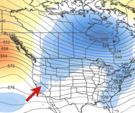
The “short-term forecast” section is dedicated to the next 5-7 days. So for this section we still have a forecast discussion of warm and dry weather as high pressure is centered over the West Coast.
The only change in the weather between today and next Thursday may be the cooler air moving in starting on Monday that will drop temperatures about 10 degrees for highs versus what we are seeing this week and weekend.
Extended Forecast
The “extended forecast” is normally for week 2 (beyond 7 days) and beyond. The extended forecast talks more generally about patterns and possible storms. The short-term section is where we get into more specifics about storms and possible snowfall amounts. So no storms in that window yet, but we may be getting closer!
In the last post we talked about the ridge over the West Coast retrograding up into the Gulf of Alaska and possibly further as we go into November, possibly helped by the MJO moving through phase 8 and into phase 1 over the next week. That is still the forecast today on the models and that would allow a trough to dig into the West Coast by the end of next week.
Over the last couple days the operational model runs have started to show a storm around next Friday. The European model has been pretty consistent on a moderate strength storm for next Fri-Sat. Here is a look at the latest total precip forecast.
The GFS model which is another major model that we use, has been back and forth on whether a storm moves in next Friday, or waits a few more days. Look at the last 4 runs of the GFS for total precipitation for next weekend.
A lot of auto-generated forecasts for weather sites and apps are tied to the GFS model. So that explains why your phone will show rain, no rain, rain, no rain, for next Friday, changing every 6 hours. The European EPS model that takes an average of 50 model runs we have found tends to be most reliable a week or more out. That model shows light amounts of precip for next Fri-Sat.
So we need a few more days to watch the trend and to get more confidence on a storm for the end of next week. But like I said, this section is to talk about potential pattern changes and potential storms, and not the specifics yet. So once this storm gets into the 5-7 day window we should have a clearer picture. I normally don’t get into a detailed snowfall forecast until within 5 days of a storm. This storm does have the potential to bring some snow to the mountains.
The main message today is that it continues to look like we will see a pattern change as we go into the month of November. The ensemble runs are suggesting we could have a pattern that allows more storms to move into the West Coast the week of the 6th. The other piece of good news is that the pattern would bring colder air so that the ski resorts can start making snow. Most of the bigger resorts will try to get snowmaking started the first week of November so that they can at least open with man-made snow by Thanksgiving.
Fantasy Range:
Beyond 2 weeks we may see the trough shift to the Eastern U.S.
Some people have been mentioning that the cooling water in the Pacific is starting to look like 2010-11. That was a cold and very snowy season for us. The sea surface temps are cooling in the Eastern Pacific and along the equator, but not as cold as October 2010. Also, notice the colder water to the West of Australia this Fall that can affect the weather pattern over the U.S.
We will keep watching the trend as we go through the Winter. The prolonged Winter pattern of cold and a trough along the West Coast in the Spring of 2011 that kept snow falling into June, was attributed to the cold Eastern Pacific by some meteorologists.
When I talk to people about that season they only seem to remember all the cold and snow, but they always seem to forget the lack of snow in the heart of the Winter that year. Take for example Squaw Valley’s snowfall. By New Years Day they had picked up 270 inches so far that season. But for 6 weeks from 1/1 until 2/15 it only snowed a total of 16 inches. I remember people declaring the Winter was over and a dud by mid-February. Then from 2/15 through 6/10 it snowed over 500 inches.
So no matter what happens over the Winter season the cold Eastern Pacific can make the Spring snowfall interesting some years….
That’s all I have for now. I will update more often as we close in on the potential storm for the end of next week.
Stay tuned…Snow Forecaster Bryan Allegretto


